Facts about Comoros
Official languages: Arabic, French
Capital: Moroni
Area: 2,170 km²
Population: 773,407 residents
Population density: 356.41 residents per km²
Currency: KMF
Internet TLD: .km
ISO codes: KM, COM, 174
The telephone code for Comoros is +269
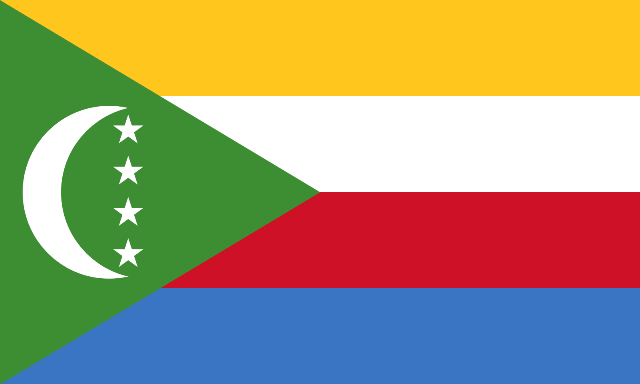
Flag of Comoro
The Comoro Islands lie between Madagascar and Africa. Their current flag was adopted in 2001 after a number of changes. The flag had three variations from 1978 to 2001, all very similar and consisting of a green leaf, a white crescent and four white five-pointed stars. Today’s version is complemented by four horizontal stripes in yellow, white, red and blue. The traditional symbols of Islam – the crescent moon and stars, are now placed in a green pole wedge. The individual stripes together with the four stars represent the four main Comoros islands – Mohéli, Mayotte, Anjouan and Grande Comore, with Mayotte officially a French overseas territory, but Comoros does not recognize this status.
The Comoros (Comorian قمر Komori, French Comores; officially since 2001 Union of the Comoros) form a federal island state in the Indian Ocean at the northern exit of the Mozambique Strait between Mozambique and Madagascar. They comprise three of the four main islands of the Comoros Archipelago. These are Grande Comore (Njazidja), Anjouan (Nzwani), Mohéli (Mwali) and some smaller islands. The fourth main island of Mayotte is administered by France, but claimed by the Comoros Republic.
The Comoros belong geographically to East Africa and lie between Madagascar’s northern tip and the African mainland.
The Comoros gained independence from France in 1975 and since then has seen an eventful history with coups and secessionist efforts. Its residents are of mixed, predominantly East African and Arab ancestry, and the majority are Muslim. The country’s name is derived from the Arabic Juzur al-Qamar (جزر القمر), which means something like “lunar islands”.
The road network is in a desolate general condition, caution is required when driving after dark. The fuel supply is not always guaranteed. The flight connections between the islands are operated by two private airlines, one of which is on the black list of unsafe airlines. The intra-Comorian flight connections and telecommunications are still irregular and often disrupted. Small motorized boats (so-called kwassa-kwassa) that provide transport between the islands are not a safe means of transport.
The Comoros are a strongly Islamic country. Travelers are expected to conform to the codes of conduct and morals of the greater part of the population. You shouldn’t wear shorts, cut-out dresses or miniskirts in the city. The consumption of alcohol in public is prohibited. Women should avoid bathing on public beaches, especially during Ramadan.
Biggest Cities of Comoros by Population
Comoros is an island nation located in the Indian Ocean with a population of just over 800,000 people. The largest city in Comoros is Moroni which has a population of around 55,000 people. This vibrant coastal city offers plenty for visitors to explore including its vibrant markets selling local produce and crafts as well as several cultural attractions such as the Old Town or historic sites like the Sultan’s Palace! There are also several outdoor activities such as diving in Anjouan or exploring the Moheli National Park!
Moutsamoudou is another major city in Comoros with a population of just over 16,000 people. This bustling port city offers plenty for visitors to explore including its vibrant markets selling fresh produce and local crafts as well as several cultural attractions such as traditional villages and sacred sites like Grand Mosque! There are also several outdoor activities such as kayaking through Ngazidja Lagoon or camping at Mount Karthala National Park!
Fomboni is another major city located in Comoros with a population of just under 10,000 people. This coastal city offers plenty for visitors to explore including its vibrant markets selling fresh produce and local crafts as well as several cultural attractions such Grand Mosque of Fomboni or historic sites like Chezani Fort! There are also several outdoor activities such as trekking through Moya Forest Reserve or visiting Moheli Marine Park!
| # | City | Population | Latitude | Longitude |
| 1 | Moroni, Comoros | 42,983 | -11.7022 | 43.2551 |
| 2 | Moutsamoudou, Comoros | 23,705 | -12.1667 | 44.3994 |
| 3 | Fomboni, Comoros | 15,077 | -12.2876 | 43.7434 |
| 4 | Domoni, Comoros | 14,620 | -12.2569 | 44.5319 |
| 5 | Tsimbeo, Comoros | 12,583 | -12.2058 | 44.4647 |
| 6 | Adda-Doueni, Comoros | 10,969 | -12.2925 | 44.4972 |
| 7 | Sima, Comoros | 10,485 | -12.1956 | 44.2767 |
| 8 | Ouani, Comoros | 10,290 | -12.1355 | 44.4249 |
| 9 | Mirontsi, Comoros | 10,279 | -12.1567 | 44.4081 |
| 10 | Mkiriwadjumoi, Comoros | 8,860 | -12.3109 | 44.437 |
| 11 | Koni-Djodjo, Comoros | 8,220 | -12.2297 | 44.4817 |
| 12 | Moya, Comoros | 7,640 | -12.3067 | 44.4378 |
| 13 | Mbeni, Comoros | 6,627 | -11.5014 | 43.3775 |
| 14 | Mitsamiouli, Comoros | 6,213 | -11.3847 | 43.2844 |
| 15 | Barakani, Comoros | 6,200 | -12.1386 | 44.4303 |
| 16 | Chandra, Comoros | 5,756 | -12.195 | 44.4647 |
| 17 | Ouellah, Comoros | 5,589 | -11.3903 | 43.3319 |
| 18 | Mramani, Comoros | 5,237 | -12.3464 | 44.5286 |
Comoros: Nyazidja
The capital of the Comoros, which is called Moroni, is on Nyazidja.